
East Wellington Road - Transportation Upgrade
WHAT'S NEW?
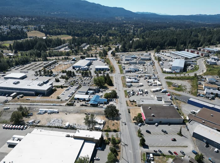
This summer will see construction on the East Wellington Road and Madsen Road corridors! The proposed transportation upgrades will address traffic delays through new traffic signal installations, lack of sidewalks, cycle facility upgrades while ensuring reliable and modernized services for the community.
While the primary focus is on transportation upgrades on East Wellington Road and Madsen Road, the project will also include improved cycle connections to the Nanaimo Parkway trails, Buttertubs Marsh and Bowen Park
In addition the project incorporates safety and accessibility improvements aligned with current design standards. The road restoration has been carefully planned using best practices from the BC Community Road Safety Toolkit, featuring several key improvements: optimized lane widths, pedestrian crossings, protected cycling facilities, and enhanced intersection designs with tactile warning surfaces. These features work together to create a safer, more inclusive environment for all road users, including pedestrians, cyclists, and drivers.
Key benefits of the project include:
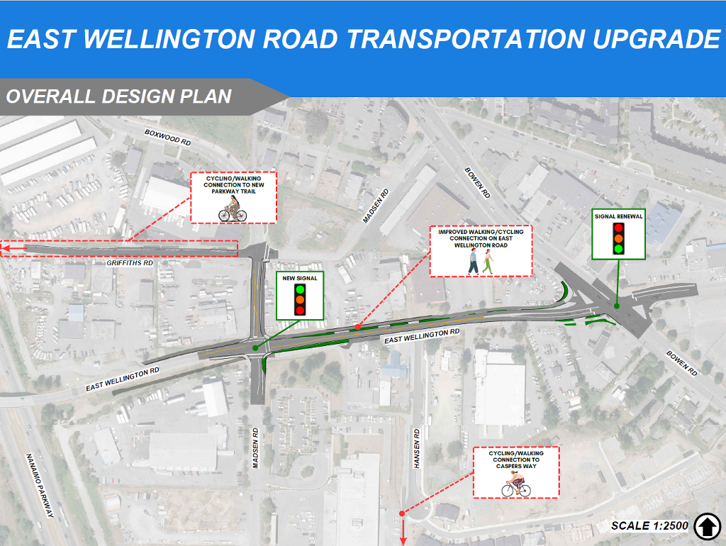
- New traffic signals at Madsen Road and East Wellington Road intersection.
- Traffic signal replacement at Bowen Road and East Wellington Road intersection.
- New pedestrian sidewalks on East Wellington Road (north side), Madsen Road (east side) and connections to Caspers Way.
- Provision of dedicated cycle facilities and crossings.
- Improved safety through redesigned road features, such as protected crossings and better lane configurations.
- Enhanced mobility and accessibility for people of all ages and abilities.
- Streetscape updates that create a more welcoming and connected public space.
By coordinating these infrastructure renewals into a single project, the City will achieve cost savings through efficient construction scheduling and reduced disruption to residents.
WHAT’S INCLUDED?
- Intersection Improvements: New traffic signals at the intersection of East Wellington Road and Madsen Road.
- Traffic Signal Improvements: Replacement of the existing traffic signals at Bowen Road and East Wellington Road intersection.
- Sidewalk Improvements: Installation of approximately 245m of new sidewalk on the north side of East Wellington Road.
- Cycling & Walking Improvements: Bike crossings and crosswalks for East Wellington Road, Madsen Road, Griffiths Road and connections to Caspers Way.
- Corridor Mobility Improvements for All Users: The City of Nanaimo aims to increase safety and comfort for people who walk, bike, take transit, and drive. These improvements include new sidewalks, crossings, and separated bike lanes throughout the extent of the project.
Stay Connected
- Progress
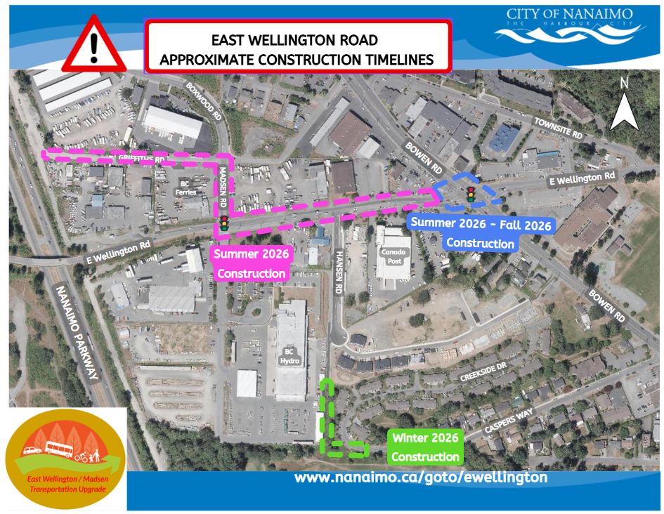
CONSTRUCTION UPDATE:
Summer, 2026 - East Wellington Road transportation project to commence January & February 2026 - detailed design work still in progress
March & April, 2026 - contract tendering and contract awardMay 2026 - on site construction commences
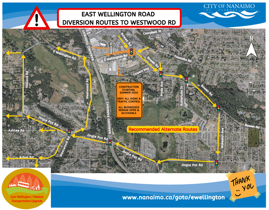
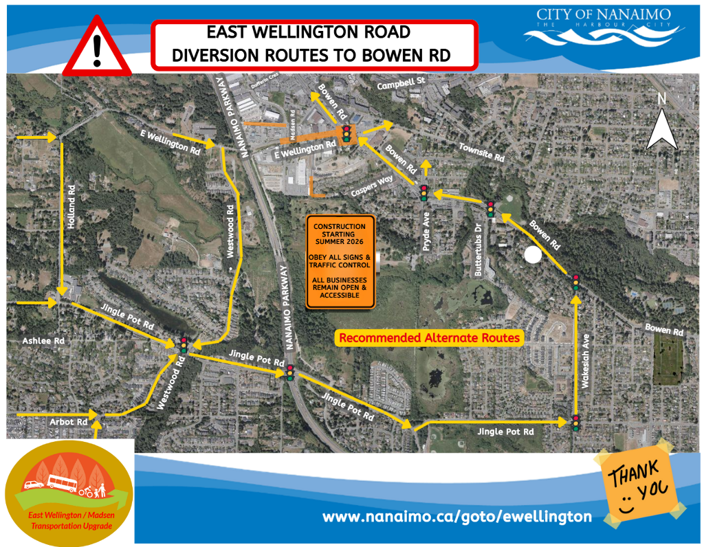
To avoid delays on East Wellington Road, drivers should choose alternative diversion routes to steer clear of roadworks during the construction period.
PROJECT SCHEDULE
Phase: Timeframe: Preliminary Design Complete Public Consultation In progress Detailed Design In progress Tendering Spring 2026 Construction Summer 2026 - Winter 2026 - Documents
DESIGN DOCUMENTS:
Cross-Sections:
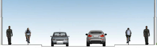
Typical Section - East Wellington Road @ Madsen Road
A new multi use path will segregate cyclists and pedestrians from motor vehicles

PLANNING DOCUMENTS:
Nanaimo Transportation Master Plan
Council, staff, and residents have supported complete streets principles dating back to 2002. Over 17 documents and plans have been created over the past 16 years, referencing complete streets or speaking to the principles of creating a greener, sustainable, and multi-model network that accommodates and moves people - not only motorists.
In 2014, Nanaimo’s City Council approved the Nanaimo Transportation Master Plan (NTMP), which included recommendations to create complete street standards and to expand the cycling network.
- Details
EAST WELLINGTON ROAD & MADSEN ROAD TRANSPORTATION UPGRADE FAQ
Additional Construction FAQs that are not project specific, can be found here: City Construction Project FAQSQ1: Complete Streets?
What are Complete Streets?
- “Complete Streets” is an international initiative and design approach that requires streets to be planned and operated to enable safe and comfortable use for all ages and abilities.
- Complete Streets move people, not just cars.
- The initiative recognizes that streets have different roles, functions, and characteristics depending on their context.
- A Complete Street aims to provide balanced mobility for a range of users including pedestrians, bicyclists, vehicles and transit in a shared roadway experience.
- Nanaimo's Council, staff, and residents have supported complete streets principles dating back to 2002.
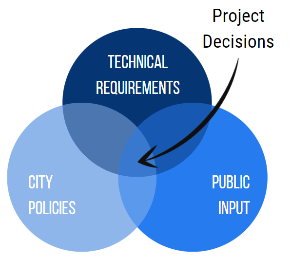
Q2: How are decisions made?
As part of the decision-making process decisions are made based on three components:
- Technical Requirements - what infrastructure best meets the area's needs, where it can fit, and what impacts it will have to the immediate and surrounding area
- City Policies - how City initiatives and activities are implemented
- Public Input - local knowledge of the community
Q3: Why Change?
Why are the road upgrades along this project required?
- The East Wellington Road corridor is an industrial road connection from Madsen Road to Bowen Road. It is identified for active transportation upgrades, pavement renewal, traffic signal installation and replacement, and accessibly improvements.
- This project combines all of the planned needs into one comprehensive project.
- The City’s goal is to provide a greener, more sustainable, multi-modal network that accommodates all user groups safely and efficiently.
- Nanaimo is one of the fastest growing communities in BC. This means the City must plan ahead to ensure sustainable modes of transportation are incorporated into today’s projects for future uses.
- Q4: Sidewalks? Will there be sidewalks on East Wellington Road?
- Yes! The design proposes a continuous sidewalk on the north side of East Wellington Road for the extent of the project from Madsen Road to Bowen Road.
- The aim is to provide a comfortable and functional environment that is universally accessible for pedestrians of all ages and abilities.
Q5: Cycle Tracks?
Are there going to be designated routes for cyclists on East Wellington Road and Madsen Road?
- Yes! The cycle tracks are designed to strengthen connections to destinations like the the Nanaimo Parkway trails, Buttertubs Marsh and Bowen Park and vice versa.
- This project proposes continuous routes for cyclists from the new Nanaimo Parkway trail, along Griffiths Road, on the east side of Madsen Road, on the south side of East Wellington Road, continuing on the south side of Hansen Road into Caspers Way.
- Based on public feedback from other complete streets projects, the preference is for cyclists to be physically separated from the road. This is being accommodated where possible.
- Physical separation encourages comfort for users of all ages and abilities.
Q6: Accessibility?
What accessibility features will the design include for more vulnerable road users?
- Tactile warning surface indicators at all crosswalks and bus stops to aid the visually impaired.
- Raised crossings will be incorporated at local roads to provide a safer and more consistent surface for wheel chairs and other wheeled modes.
Q7: Safety?
a) What safety features will the design include?
- A lot of the safety improvements incorporated into the East Wellington Road project that are from the Provincial Government’s BC Community Road Safety Toolkit, created in the hopes of working towards Vision Zero in communities throughout the province.
- Pedestrian & Cycling Safety Improvements included in this project:
- Tactile Warning Surface Indicators (TWSIs)
- Sidewalks (Module1 - Page5)
- Protected Bicycle Lanes (Module1-Page12)
- Raised Crossings (Module1 - Page26)
- Conflict Paint (Module1 - Page27)
- Roadway Safety Improvements included in this project:
- Narrowed Vehicle Lanes (Module2 - Page7)
- Smaller Corner Radii (Module2 - Page24)
b) Won’t cars block the sidewalk and bike lanes at local roads?
- The same conflict between a car and the pedestrian or cyclist exists today. The only difference is the car will visibly be entering the sidewalk instead of the user stepping out onto the road. See Raised Crossings above.
Q8: Parking?
Will parking be provided along East Wellington Road and Madsen Road?
- There will be no on street parking on this section of East Wellington Road and Madsen Road as the primary use of these industrial collector streets is to move goods.
Q9: Encroachments?
Will the improvements be utilizing the City right-of-way up to the property line?
- The proposed design uses the full road right-of-way to provide the corridor improvements.
- Where possible, the design has meandered sidewalks.
Q10: Narrowing?
Will East Wellington Road and Madsen Road be narrowed?
- The design will maintain a 2-3 lane cross-section with one lane in each direction and a centre turn lane where needed.
Q11: Maintenance?
How will sidewalks and boulevards be maintained?
- As per the City’s current bylaw, snow clearing of sidewalks is the responsibility of the adjacent property owner.
The City is expecting that, similar to the current conditions today, that boulevard maintenance will be the responsibility of the adjacent homeowners.
Q12: Environment?
Will the improvements have environmental impacts?
- Environmental impacts during construction will be mitigated through the preparation and use of an environmental protection and stormwater management plan.
Q13: When?
When will this be built?
- Construction of the East Wellington Road transportation upgrades will start in Summer 2026.
- Construction of bike lanes on Madsen Road and Griffiths Road are unknown at this time.
Q14: Construction Inconveniences?
How will this affect my business?
- All business and property accesses will remain open during construction; we will work with you ahead of time if we foresee there being an issue.
- Construction is never convenient and can often cause frustration, so we ask residents and businesses (including clientele) to please exercise patience and understanding as the crews work to renew the utilities and roadway.
- Everyone is always in a hurry. Please account for extra time when navigating the site and respect signage and flagpersons.
- If you're commuting, please consider using alternate routes to avoid construction completely.
- Please be respectful towards workers. Abusive conduct or comments will not be tolerated.
- Background
The East Wellington Road and Madsen Road corridor is an industrial connection from the Boxwood Road and Dufferin Crescent to Bowen Road. Caspers Way and Griffiths Road provide further connections to a number of facilities including the Buttertubs Marsh and Bowen Park as well as to a section of the Parkway Trail network.
Give feedback on accessibility. Submit your feedback through our online accessibility feedback form. Help us understand barriers people face when accessing City services.
You can attach files to help explain the barrier you faced in the form, like: a video, voice recording or photos. If American Sign Language (ASL) is the best way for you to communicate, upload a video of yourself using ASL into the form.
Please include: what you were trying to access, where the barrier happened, what the barrier was and any recommendations you might have.
Help us improve our website
Important Information About Privacy
Information collected on this form is done so under the general authority of the Community Charter and Freedom of Information and Privacy Protection Act (FOIPPA), and is protected in accordance with FOIPPA. Personal information will only be used by authorized staff to fulfill the purpose for which it was originally collected, or for a use consistent with that purpose.
For further information regarding the collection, use, or disclosure of personal information, please contact the Legislative Services Office at 250-755-4405 or at foi@nanaimo.ca