
Our Coastal City: Nanaimo's Sea Level Rise Management Plan (SLRMP)
SURVEY NOW OPEN
Click the link to provide your feedback regarding proposed sea level rise adaptation strategies.
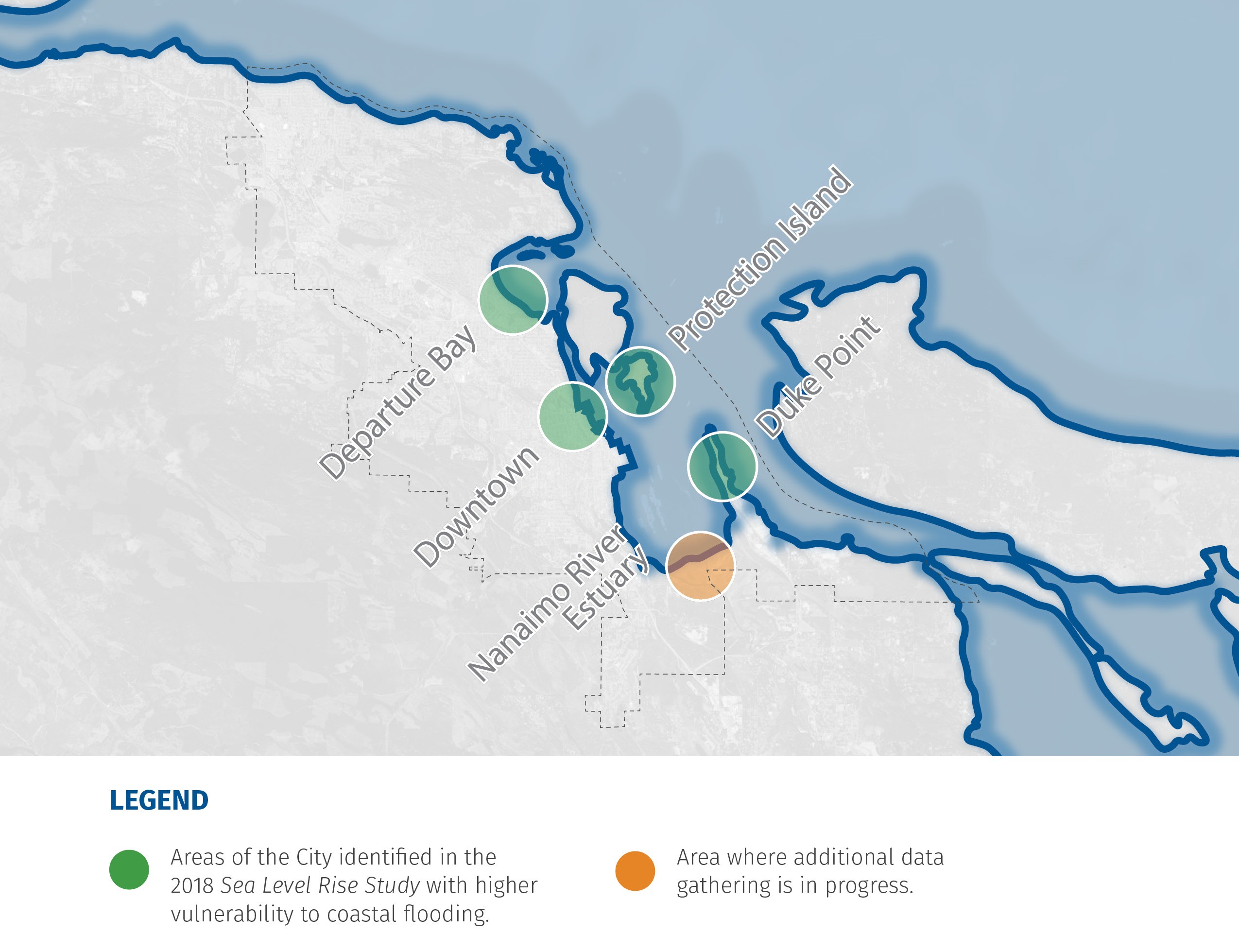
Sea level rise, caused by climate change, is increasing total ocean water levels over time. As a coastal city, Nanaimo is at risk from rising sea levels and coastal flooding. In 2018, the City completed a Sea Level Rise Study, which provided a high level overview of sea level rise risk areas. The SLRMP will focus on the vulnerable areas identified in the 2018 study (see map below). The technical reports and public engagement will improve the City’s understanding of risks and help identify potential solutions.
The project is being completed in coordination with the Regional District of Nanaimo's Our Changing Coast project.
The Sea Level Rise Management Plan includes the following tasks:
Phase One (SEPT-2025 to JUL-2026)
Phase One of the Sea Level Rise Management Plan will improve our understanding of coastal risk through a number of technical studies. The technical information along with community and interest holder engagement will aid in the identification of the preferred sea level rise management options.
Probabilistic Calculation - This calculates the possibility of multiple factors such as storm surge, wind speed, and king tide, occurring at the same time and impacting coastal flooding. This will help us to understand the likelihood of an extreme event occurring.
Inundation Modeling - 2D modeling of waves will be completed to understand how wave conditions impact coastal flooding.
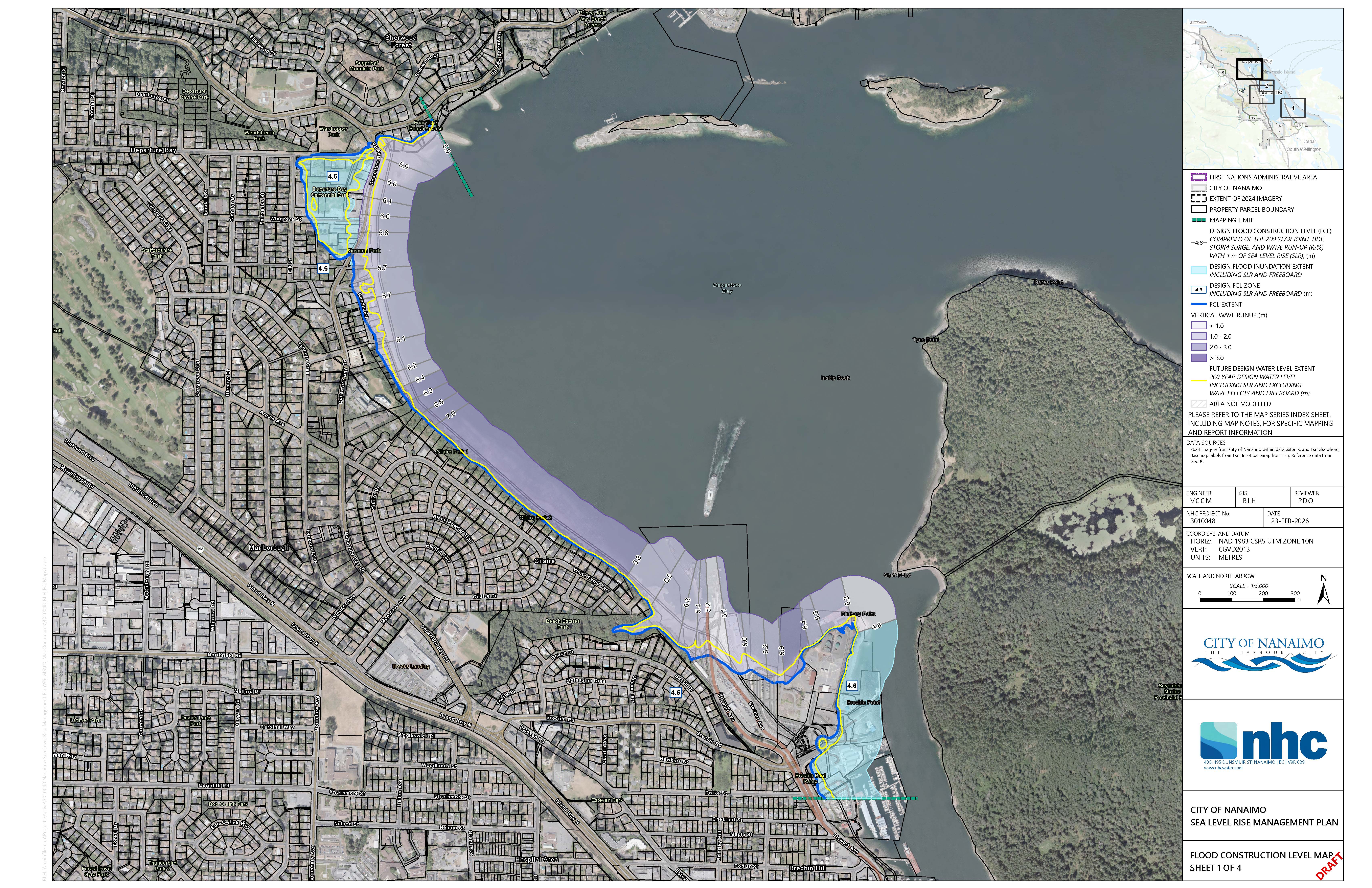
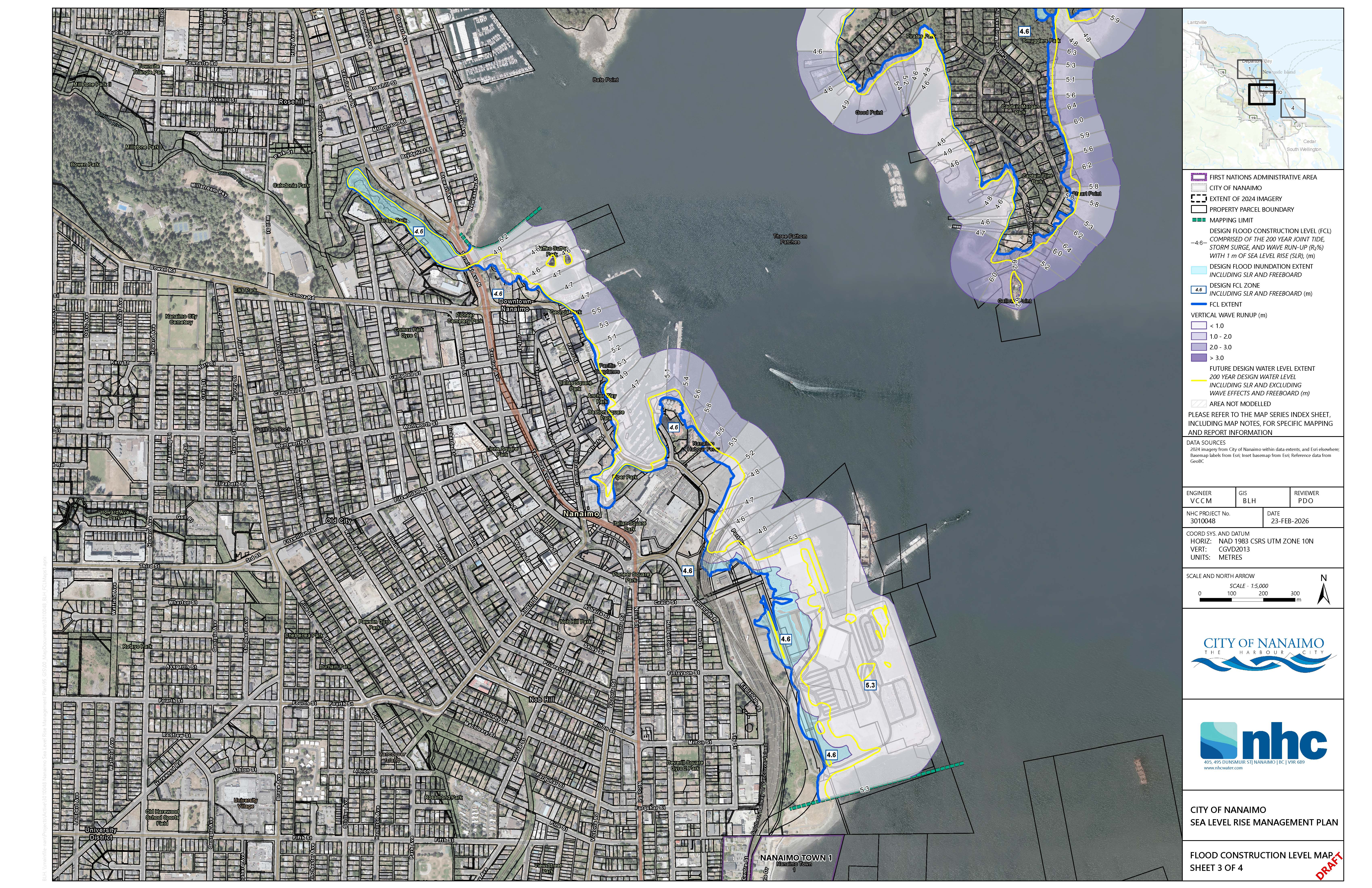
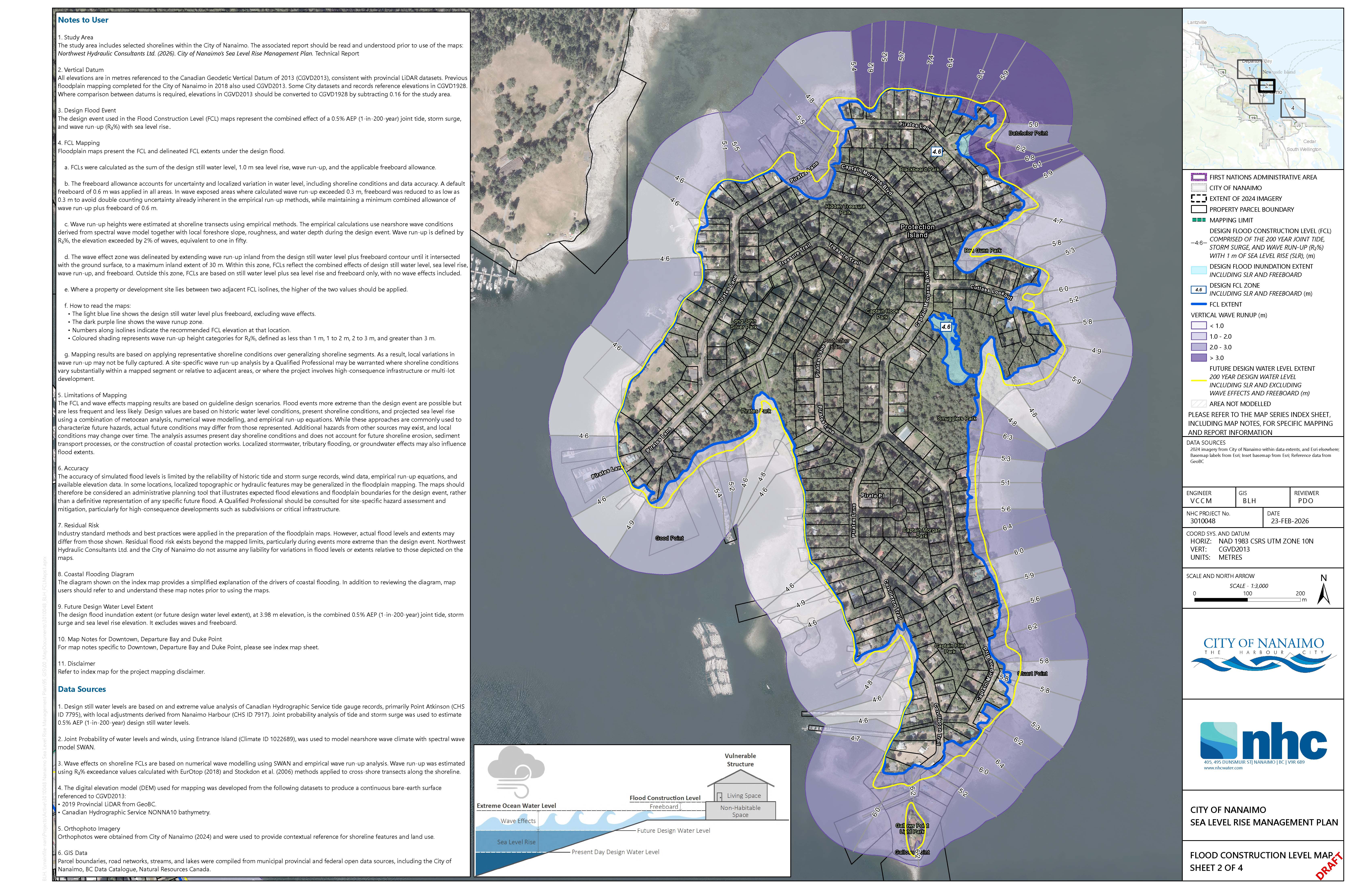
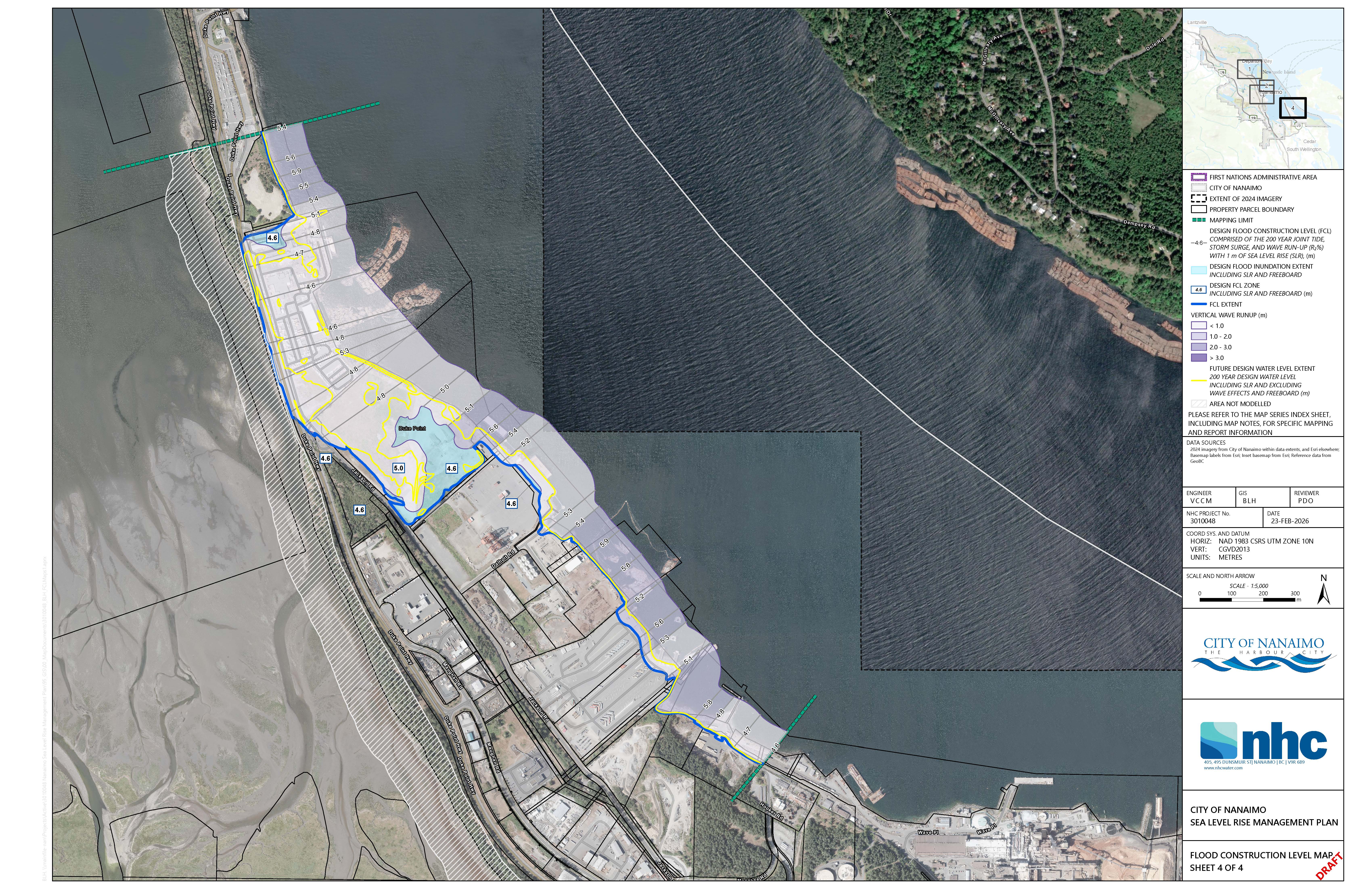
Refined Flood Construction Level Mapping - Based on the results of Steps 1 and 2, a refined coastal flood impact map will be developed to update the previous maps completed in 2018.
Economic Risk Assessment - A report detailing the financial implications of rising sea levels to coastal infrastructure and properties will help us understand the economic risk to coastal areas and evaluate management options.
Sea Level Rise Options Analysis - This will identify the preferred sea level rise management options and include community and interest holder engagement.
Phase Two (FEB-2026 to SEPT-2026)
Phase Two of the plan will focus on the development of sea level rise management options and develop a method of communicating the strategy to the public.
Coastal Erosion Monitoring and Management Strategy - This report will show the extent of coastal erosion, how we can monitor future erosion and strategies to minimize future damage, which will help us understand the rate of coastal erosion and how we can protect ourselves from its impacts
Communications Strategy - This strategy will summarize the findings from the Sea Level Rise Management Plan and communicate them in an easy to understand and engaging way.
The project is funded by grants from the British Columbia Ministry of Emergency Management and Climate Readiness (EMCR) and the Federation of Canadian Municipalities (FCM).
For more information regarding this project please contact Dave Stewart, Environmental Planner at sustainability@nanaimo.ca
Get Involved
Check out the City's Our Coastal City: Nanaimo's Sea Level Rise Management Plan GetInvolved page for more project information and opportunities to provide input on how we tackle sea level rise in Nanaimo. The next public survey will gather feedback on sea level rise adaptation options, and will be released on May 19, 2026.
https://www.getinvolvednanaimo.ca/sea-level-rise
- Progress
Phase 1 - Technical Studies (SEPT-2025 to JUL-2026)
- Probabilistic Calculation of Sea Level Rise - COMPLETE
- Inundation Modeling - COMPLETE
- Floodplain Mapping - COMPLETE
- Economic Risk Analysis- COMPLETE
- Sea Level Rise Options Analysis - In- Progress
Phase 1 - Engagement (DEC-2025 to MAY-2026)
- Listening Conversations -COMPLETE
- Interest Group Workshops - COMPLETE
- Values Survey - COMPLETE
- Option Survey - Opening May 19 to June 12 (check out the Get Involved Page for updates)
- Options Evaluation Workshop - Residents session scheduled for May 21st (see the Get Involved Page for details)
Phase 2 - Sea Level Rise Management Options & Communication Strategy (FEB-2026 to SEPT-2026)
- Coastal Erosion Monitoring and Management Strategy - In-Progress
- Communications Strategy
Sea Level Rise Management Plan Report to Council (SEPT-2026)
- Documents
2026 Floodplain Maps
Departure Bay | FEB-2026
Downtown/ Assembly Wharf | FEB-2026
Protection Island | FEB-2026
Duke Point | FEB-2026
Educational Materials
(Full Version) Building a Toolkit for Coastal Adaptation in the City of Nanaimo | MAY-2026
(Summary) Our Coastal City: An Introduction to Coastal Climate Adaptation in the City of Nanaimo | FEB-2026
Staff Reports
Staff Report- Sea Level Rise Management Plan Grant Applications | DEC-2024
Background Documents
Sea Level Rise Study Report | DEC-2018
Sea Level Rise Study 2100 Flood Construction Level Mapping | DEC-2018
Climate Change Resiliency Strategy | 2020
Sea Level Rise Development Permit Guidelines | 2022
RDN Climate Change Projections | 2023
Integrated Action Plan | 2023
Phase 1 Engagement Summary | 2026
- Details
- Background
In 2019, the City of Nanaimo completed a Sea Level Rise Study which provided a high-level vulnerability assessment of the City's coastline. The Study includes sea level rise projections for 2050 and 2100; an assessment of potential coastal erosion impacts and defines a Flood Construction Level (FCL) along the City's shoreline for 2018 and 2100. Results from the Study show that there are low-lying areas along the coastline, which are vulnerable to sea level rise. The 2019 study was a 'strategic level assessment' and did not include 2D inundation modeling. The project team that completed the 2019 study recommended, further analysis be carried out in specific low-lying populated areas (Departure Bay, Protection Island and downtown areas) that will more accurately define inundation limits, as well as potential flooding. In order to plan for and manage potential sea level rise in those vulnerable areas identified, a Sea Level Rise Management Plan (SLRMP) was recommended. The scope of work proposed is based on recommendations included in the 2019 Sea Level Rise Study, which were carried forward into the City's 2020 Climate Change Resiliency Strategy and 2023 Integrated Action Plan. The development of a SLRMP is included as a priority action within the Integrated Action Plan.
Give feedback on accessibility. Submit your feedback through our online accessibility feedback form. Help us understand barriers people face when accessing City services.
You can attach files to help explain the barrier you faced in the form, like: a video, voice recording or photos. If American Sign Language (ASL) is the best way for you to communicate, upload a video of yourself using ASL into the form.
Please include: what you were trying to access, where the barrier happened, what the barrier was and any recommendations you might have.
Help us improve our website
Important Information About Privacy
Information collected on this form is done so under the general authority of the Community Charter and Freedom of Information and Privacy Protection Act (FOIPPA), and is protected in accordance with FOIPPA. Personal information will only be used by authorized staff to fulfill the purpose for which it was originally collected, or for a use consistent with that purpose.
For further information regarding the collection, use, or disclosure of personal information, please contact the Legislative Services Office at 250-755-4405 or at foi@nanaimo.ca