
Estevan Road and Princess Royal Avenue Street Improvements
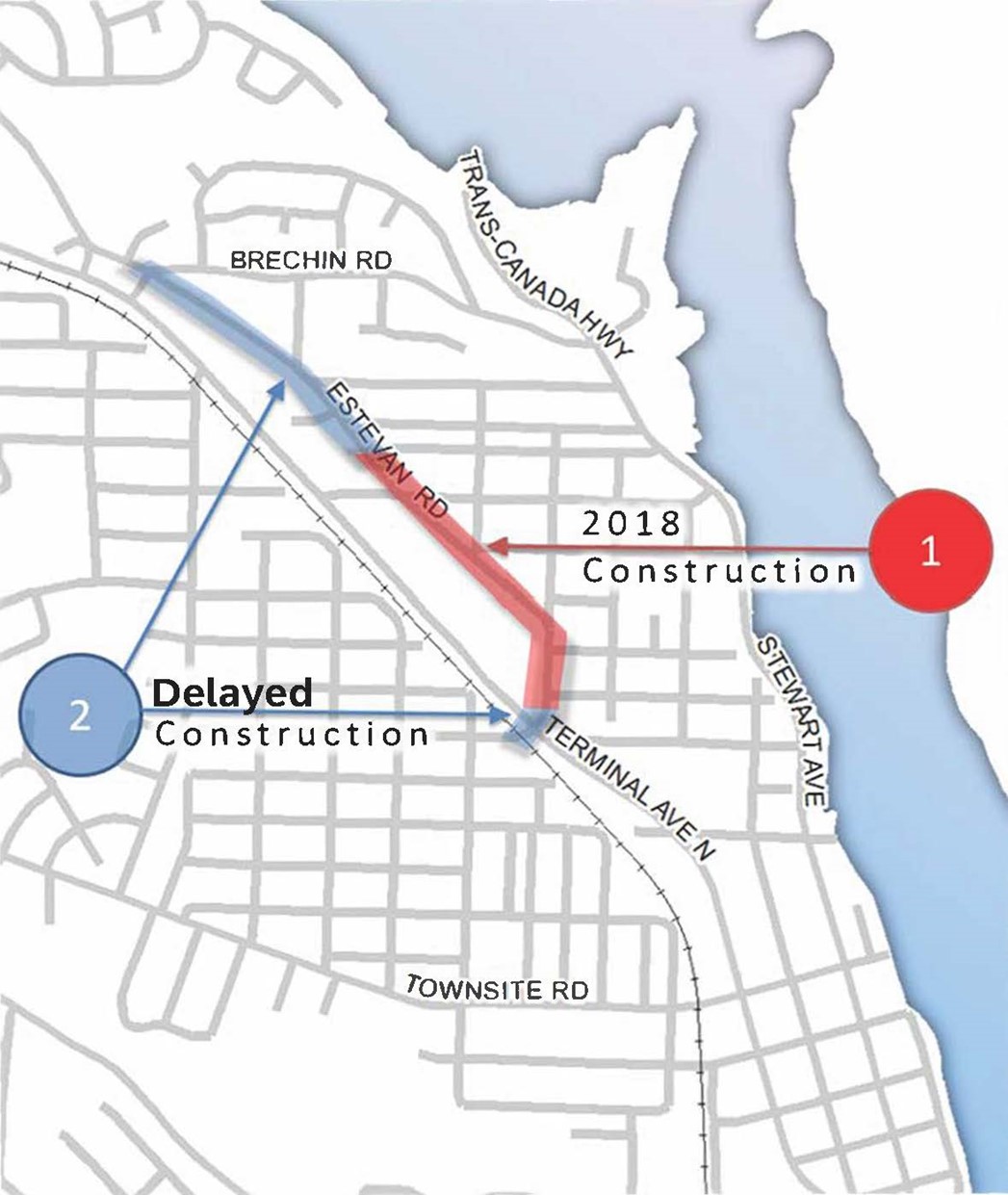
Pedestrian and cycling improvements planned for the Estevan Road and Princess Royal Avenue corridor will be completed in a phased approach over the next two years. Phase I work from Terminal Avenue to Maple Street is scheduled to begin construction in June of 2018 as part of Terminal Avenue’s pavement resurfacing while Phase II from Maple Street to Brechin Road will be constructed in 2019. The planned work aligns with the Nanaimo Transportation Master Plan (NTMP) and recommendations from the Newcastle and Brechin Neighbourhood Plan (NBNP) and includes:
- Creation of approximately 1.4 km of dedicated cycling facilities,
- Reduction of the roads’ existing four lane cross section to two lanes,
- Construction of concrete and landscaped center medians,
- The addition of two way center left turn lanes,
- Improvements to crosswalks and transit stops.
Contact
If you have any comments or questions on the planned improvements, please contact us at 250-754-4251 or email EngineeringInfo@nanaimo.ca.
- Progress
Project Phase Approximate Date Phase 1 (complete)
Phase 2 Being completed together with property re-development proposal by École Océane at 1951 Estevan Road
- Documents
- Details
 The Estevan Road and Princess Royal Avenue Street Improvement Project is located in central Nanaimo’s Brechin Hill neighbourhood and runs parallel to Terminal Avenue from Brechin Road to Terminal Avenue. The roadway is classified a Major Collector and consists primarily of commercial properties on the west side and residential properties to the east.
 Public transit service along the corridor is provided every 35 minutes with bus stops located at Hemlock, Larch, Maple and Brechin. There are six existing crosswalks throughout the corridor, one of which includes pedestrian activated flashers. Prior to construction of the Nanaimo Parkway, traffic volume through the corridor was 8,500 vehicles per day, approximately twice the current level. With the reduction in traffic and speeds averaging less than 50 km/hr, capacity of the existing four lanes is underutilized and no longer required.
In keeping with the NTMP and recommendations in the NBNP, the street improvement project will support sustainability and connectivity while providing traffic calming, street character and greater pedestrian and bicycle safety.
 To improve traffic flow and allocate space for approximately 1.4 km of new dedicated bike lanes, the existing four lane road will be reduced to two complete with centre left turn lanes and medians at key locations. This change is anticipated to calm traffic by removing left turn movements from through traffic and narrowing the corridor. The new cycling routes will connect to existing bike lanes at the north end of the corridor as well as future bike routes at the midpoint and south end of the project.
To improve the streetscape and address pedestrian safety, landscaped and concrete centre medians are proposed at key locations. Several of the corridor’s existing crosswalks will be relocated to coincide with the medians and create two-stage pedestrian crossings. The medians provide both a physical barrier to motorists and pedestrians a midway refuge from traffic.
An overall plan of the project with section highlights can be viewed by clicking the image below:

The project area is summarized in the following four sections:
Brechin Road to Quadra Avenue
This section of roadway will have a dedicated 1.5m wide bike lane added to the north bound lane but due to the absence of sidewalk the south bound lane will receive a 1.5 meter multi-use shoulder for both pedestrians and cyclists. To support minimum widths for safe travel and improve transit service a section of pavement will require widening and a new raised bus stop and bench will be constructed just south of the entrance to École Océane’s parking area.
Quadra Avenue to Poplar Street
The multi use and dedicated bike lanes continue through this segment of the project. Future cycling improvements and way finding signs planned for Drake Street has it scheduled to become the recommended bike route between the BC Ferries Departure Bay Terminal and the E&N Trail. With this in mind, the existing mid block crosswalk south of Quadra Street will be relocated to Drake Street for a more effective pedestrian and cyclist crossing alignment. An asphalt pad complete with cyclist stop bar on the west side of Estevan Road across from Drake Street will support a new multi-use trail connection to the existing pathway. The new trail will incorporate a short section of gravel walkway to provide better access to École Océane school grounds. Sidewalk along the west side of Estevan Road begins south of Maple Street which allows the south bound multi-use lane to become a dedicated bike lane. To accommodate the new bike lanes the existing three and four lane road cross sections will be reduced to two with a center left turn lane at Poplar Street.
Poplar Street to Hemlock Street
The intersection of Poplar Street & Estevan Road will receive left turn guidance lines to assist in navigating the skewed intersection. South of Poplar Street, the existing section of four lane road will be reduced to two with two way centre left turn lanes and a continuation of the dedicated bike lanes. As recommended in the Neighbourhood Plan, both concrete and landscaped centre medians complete with trees are proposed at key locations. The medians will enhance the streetscape while improving pedestrian safety by way of two-stage crosswalk crossings. There are three existing crosswalks in the block between Poplar and Larch. To eliminate redundancy and improve traffic flow the existing mid block crosswalk will be removed. The Poplar Street intersection crossing will be relocated south of its current location and given a two-stage median crossing complete with pedestrian activated flashers. The crossing north of Larch Street will be relocated to south side of the intersection to better coincide with the existing bus stops and benefit from a two-stage crossing at the proposed centre median.
Hemlock Street to Terminal Avenue
Road lanes are reduced from four to two with new centre left turn lanes at Hemlock and Jumper Streets. South bound, dedicated bike lanes continue through to Terminal Avenue however north bound they begin at Juniper Street. South of Hemlock Street, a proposed landscaped centre median complete with trees will incorporate the existing crosswalk in a two-stage pedestrian crossing.
Second phase project improvements scheduled for completion with the Terminal Avenue Road Rehabilitation project in 2018 include:
- A small multi-use path link on the east corner of the Terminal Ave to provide a connection to future bike routes planned for St George Street and Vancouver Avenue;
- A crosswalk at the south leg of the intersection to complete safe crossing paths in all directions of the intersection;
- Modified at-grade traffic islands to provide a smoother transition for cyclists, wheelchairs and scooters;
- Addition of dashed lines known as Elephants Feet to the south and west legs of the intersection allowing cyclists to cross without dismounting their bicycles; and
- Extension of the dedicated north bound bike lanes from Terminal Avenue to Juniper Street.
These intersection improvements support connectivity to the E&N Trail and future cycling infrastructure.
The approved budget for these upgrades in the 2017-2021 Financial Plan is $210,000.
FAQs
Why are centre medians proposed in some locations and yellow hatching (goring) in others?
Yellow hatching (hash marks) on the roadway identify areas that vehicles are restricted from travelling on and are used as a guide to direct traffic through cross-section changes in the road. These are typically used to support the introduction of left turn lanes. While concrete centre medians provide a physical separation and introduce the potential for streetscape improvement, they cost significantly more to construct. In some curved areas of the road, centre medians do not work as heavy transport trucks would track over them and continually damage the median over time.
Why is on-street parking not provided as recommended in the Neighbourhood Plan?
The existing right-of-way is not wide enough to include additional parking at this time, however as development occurs additional road dedication will be taken and frontage works may include additional parking and planted curb extensions where appropriate.
Why is there only one pedestrian activated flasher along the project corridor? Shouldn’t they all be upgraded?
Pedestrian activity is expected and legal at intersecting streets while it is less so at mid-block crossings. Therefore, to help alert drivers to uncharacteristic pedestrian activity only the midblock crosswalk will receive flasher treatment.
- Background

One of the oldest neighbourhoods adjacent to Nanaimo’s downtown core, Brechin Hill has historically played a significant role as the City’s transportation hub and it continues to today as a home to floatplanes, ferries and pleasure craft.
The Brechin area has seen a mix of uses through the years. In 1893 a provincial jail capable of housing up to 100 prisoners and managed by R. William Stewart for which Stewart Avenue is named was constructed at the corner of Stewart Avenue and Townsite Road. Resident prisoners were tasked with community work which included planting many of the trees in the area. Initial industrial workings in the early 1900’s include fish salteries operated primarily by Japanese-Canadians and the Brechin Coal Mine located at what is now the Departure Bay Ferry Terminal. Canneries and shipyards followed shortly after the establishment of the salteries and mine which lead to the development of a small settlement.
 Miner cottages lined the shores of Brechin Hill and slowly transformed the area into a residential community. Residents such as R. William Stewart, Albert Dunn and former Mayor Frank Ney helped the Brechin - Newcastle area became known as one of Nanaimo’s more affluent neighbourhoods. With eight per cent of its historical housing stock (built prior to 1946) still in use today the area has transitioned from one focused on mining and industrial activity to that of older residential homes with commercial and marine oriented activity.
 Today, the area has transitioned from one focused on mining and industrial activity, to that of older residential homes with commercial and marine oriented activity. Given its proximity to downtown, and the substantial movement of vehicular traffic, a neighbourhood plan respecting its history with consideration for sustainable future development is of prime importance.


Give feedback on accessibility. Submit your feedback through our online accessibility feedback form. Help us understand barriers people face when accessing City services.
You can attach files to help explain the barrier you faced in the form, like: a video, voice recording or photos. If American Sign Language (ASL) is the best way for you to communicate, upload a video of yourself using ASL into the form.
Please include: what you were trying to access, where the barrier happened, what the barrier was and any recommendations you might have.
Help us improve our website
Important Information About Privacy
Information collected on this form is done so under the general authority of the Community Charter and Freedom of Information and Privacy Protection Act (FOIPPA), and is protected in accordance with FOIPPA. Personal information will only be used by authorized staff to fulfill the purpose for which it was originally collected, or for a use consistent with that purpose.
For further information regarding the collection, use, or disclosure of personal information, please contact the Legislative Services Office at 250-755-4405 or at foi@nanaimo.ca