Turner Road and Dover Road Bikeways

Transportation upgrades are planned for Dover, McGirr and Turner to better accommodate cyclists and other road users.  Proposed improvements include 4.9km of bicycle lanes and 1.6km of shared use travel lanes.  This 6.5km upgrade is part of the short term priority bicycle network identified in the Nanaimo Transportation Master Plan (NTMP) and will connect neighbourhood destinations and existing bike lane segments.  In the longer term, additional links are planned to make cycling a more viable way to move around North Nanaimo.

TurnerDoverBikewaysHeaderPhoto

Update – New Sidewalks on Dover Road (Blueback to Invermere)

The City will be installing new concrete sidewalks on Dover Road from Blueback Road to Invermere Road. This will result in complete sidewalks on both sides of Dover Road, from Dickinson to McGirr. In conjunction with the recent bike laning project, the additional sidewalks will provide a safe and effective means of transportation through the corridor for motorists, cyclists, and pedestrians. Additional information is available under the Progress tab below.

Contact Information

If you have any comments or questions on the planned improvements, please contact us at 250-754-4251 or email EngineeringInfo@nanaimo.ca.

  • Progress

    Through the Nanaimo Transportation Master Plan and the McGirr Elementary Safer School Travel Program the Turner Road and Dover Road corridor was identified for pedestrian and cycling enhancements.  The Turner Road and Dover Road Bikeway Project was identified as part of the long term development of the cycling network. The north side of Dover Road, between Blueback Road and Invermere Road, is the only section of Dover Road between Dickinson Road and McGirr Road that does not have sidewalk.  In the 2015 Capital Budget, the Turner Road and Dover Road Bikeway Project was scheduled for construction in 2017; however, the section of sidewalk on Dover Road, between Blueback Road and Invermere Road, was removed due to budget constraints.

    A grant application was made to the Province of British Columbia under the 2017 BikeBC Program and in March of 2017, the City of Nanaimo was advised that the application was successful and that 50% of the Turner Road and Dover Road Bikeway Project costs would be available to the City for this project.

    This project was completed in the summer of  2018.


  • Documents
  • Details

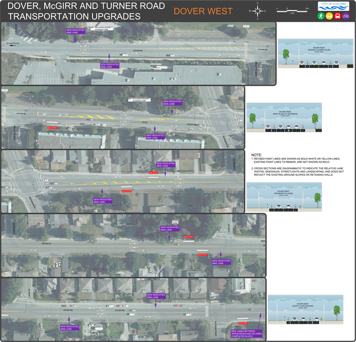
    Dover Road West  (Schook to Applecross Rd)

    • 2100m of dedicated bicycle lanes.
    • Existing on-street parking, left and right turn lanes to remain.
    • Connects commercial and residential areas along the corridor, Lantzville to the west, and McGirr Elementary in the east.
    • Connects an isolated segment of bicycle lanes between Applecross Road and Uplands Drive.
    1998DoverWest_large

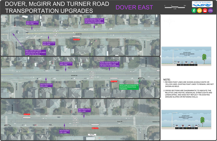
    Dover Road East (Uplands Dr to McGirr Rd)

    • 900m of dedicated bicycle lanes and due to road width constraints 180m of shared travel lane (eastbound) from Invermere to McGirr Rd.
    • Limited pavement widening between Uplands and Invermere and a curb extension at the intersection of Invermere/Dover to improve crosswalk safety.
    • Existing on street parking remains the same.
    1998DoverEast_large

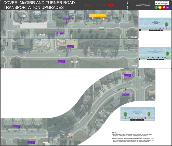
    McGirr Road (Dover to Hammond Bay Road)

    • 220m of dedicated bicycle lane (southbound) / shared travel lane (northbound) from Dover to McRob avenue.
    • 620m of shared travel lane (both directions) between McRob Ave and Hammond Bay Rd.
    • Parking removed on east side of McGirr Road, between Clarence Way and Sierra Way only.
    • Left and right turn lanes to remain the same.
    1998McGirr_large

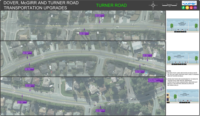
    Turner Road – (Hammond Bay to Nelson Rd)

    • 1700m of dedicated bicycle lanes in both directions except northbound at Hammond Bay and between Nelson and Glacier Way.
    • Existing on street parking, left and right turn lanes remain the same.
    1998Turner_large

    FAQs

    What is a shared lane pavement marking, or “sharrow”?

    A "sharrow" is a shared lane pavement marking. This pavement marking includes a bicycle symbol and two white chevrons. Sharrows are used to mark cycling routes, which are not dedicated, but mixed with motor vehicle traffic.

    How did you decide where to put dedicated bicycle lanes versus shared use lanes?

    On busier arterial roadways (Dover Road) bicycle lanes are preferred to sharrows as a bikeway design treatment, but not all streets have enough room for bicycle lanes due to high demand for on-street parking and/or the inability to eliminate or narrow regular traffic lanes. This is the case for a portion of McGirr and Turner roads where shared  lanes are proposed.

    What is a curb extension and why is there one proposed at Dover and Invermere?

    Curb extensions assist pedestrians crossing at intersections, by narrowing the width of the street and shortening the crossing distance. It also protects on street parking bays and reduces vehicle speeds by narrowing the road. Given the traffic volume on Dover Road, existing on street parking, and proximity of the crossing to McGirr Elementary School, it was determined to be a low cost/maintenance feature to enhance pedestrian safety. Future works may see a similar feature on the north side.

    A lot of pedestrians walk on the north side of Dover Road between Blueblack and Invermere. Why are you not building a sidewalk there?

    This was evaluated during preliminary design and ultimately the project budget could not provide this. Part of the road along here will be slightly widened to accommodate a dedicated bicycle lane, with future road rehabilitation along Dover Road potentially including raised sidewalks with curb and gutter.

    Why is parking being removed?

    There is a one block section of on-street parking being removed between Clarence Way and Sierra Way to allow the creation of a dedicated southbound bicycle lane. The grade of the road on McGirr travelling south from Dover is substantial and results in slower moving and more unstable cyclists. Constructing a dedicated lane here better protects these cyclists from faster moving vehicles. 

    Why is there a short section of shared road between Nelson Road and Glacier Way?

    With limited road width here, a dedicated bicycle lane was designed for the southbound side appreciating the slower moving cyclists up the hill approaching Linley Valley Drive. Widening the road and constructing new curb, gutter, and sidewalks here was outside of the available budget.

    It looks as though a few of the bus stop locations have been moved.

    The Regional District of Nanaimo (RDN) reviews and approves all proposed changes to bus stop locations during transporation upgrade projects such as this. Four locations on Dover road have been moved slightly to improve safety and eliminate conflicts with private driveways.

    Project Budget

    The approved budget for these upgrades in the 2016-2020 Financial Plan is $180,000

  • Background

    Dover Bikeway and Turner (McGirr) Bikeway are two projects identified in the NTMP (Nanaimo Transportation Master Plan), with the goal of encouraging and promoting cycling as a normal everyday transportation choice by providing a safe and comfortable cycling environment.

    Dover Bikeway is an east-west link across the Dover neighbourhood that will provide bicycle access for residents, and connect existing / future north-south routes to Woodgrove Centre and link to Lantzville.

    Turner (McGirr) Bikeway is a north-south link that will connect the Rutherford neighbourhood to the Dover Bikeway and provide cycling access to commercial services around the intersection of Uplands Dr and Turner Rd.

    With improvements planned for Hammond Bay Rd, Linley Valley Dr and Uplands Dr over the long -term, this project will form the foundation of a larger cycling network between Woodgrove, North Nanaimo Centre and adjacent neighbourhoods.  It will also serve to improve bicycle access to McGirr Elementary and Dover Bay Secondary.

    As a general approach, proposed improvements work within the existing road cross sections, seek to improve transit stops and crosswalks and minimize impacts on other road users and parking.

    1998Overall_large

Help us improve our website

Don't include private or financial information in this form.

Collection and use of your personal information

Information collected on this form is done so under the general authority of the Community Charter and Freedom of Information and Protection of Privacy Act (FOIPPA), and is protected in accordance with FOIPPA. Questions about the collection of your personal information may be referred to the Legislative Services Department at 250-755-4405, or via email at foi@nanaimo.ca. Please also see our Privacy Policy.